
How big is mountain? Or is this just a hill? Hold on, let me Google it–
There is no current official definition, so let me make one up. I am not afraid to climb up hills.
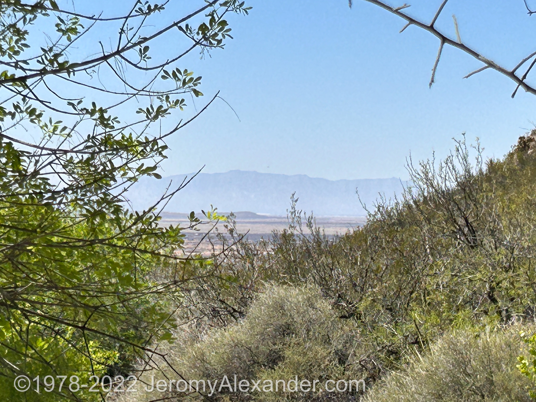
 Pictured above is the southern mountain that creates dog canyon between it and the northern mountain. I have been very excited about walking the four and a half (today I learned it’s five point two,) mile trail here into the canyon. It set the pace of my morning. Relaxing in bed (oh it felt so nice to lay down last night,) dressing in the little tent (a particular joy I’ve been able to avoid the last five weeks,) walking down to the restrooms, coming back to the site to put water on for my tea. It was a cool morning, considering it was full day light, yet the the sun had not risen over top the mountain peaks to my east (not hills…)
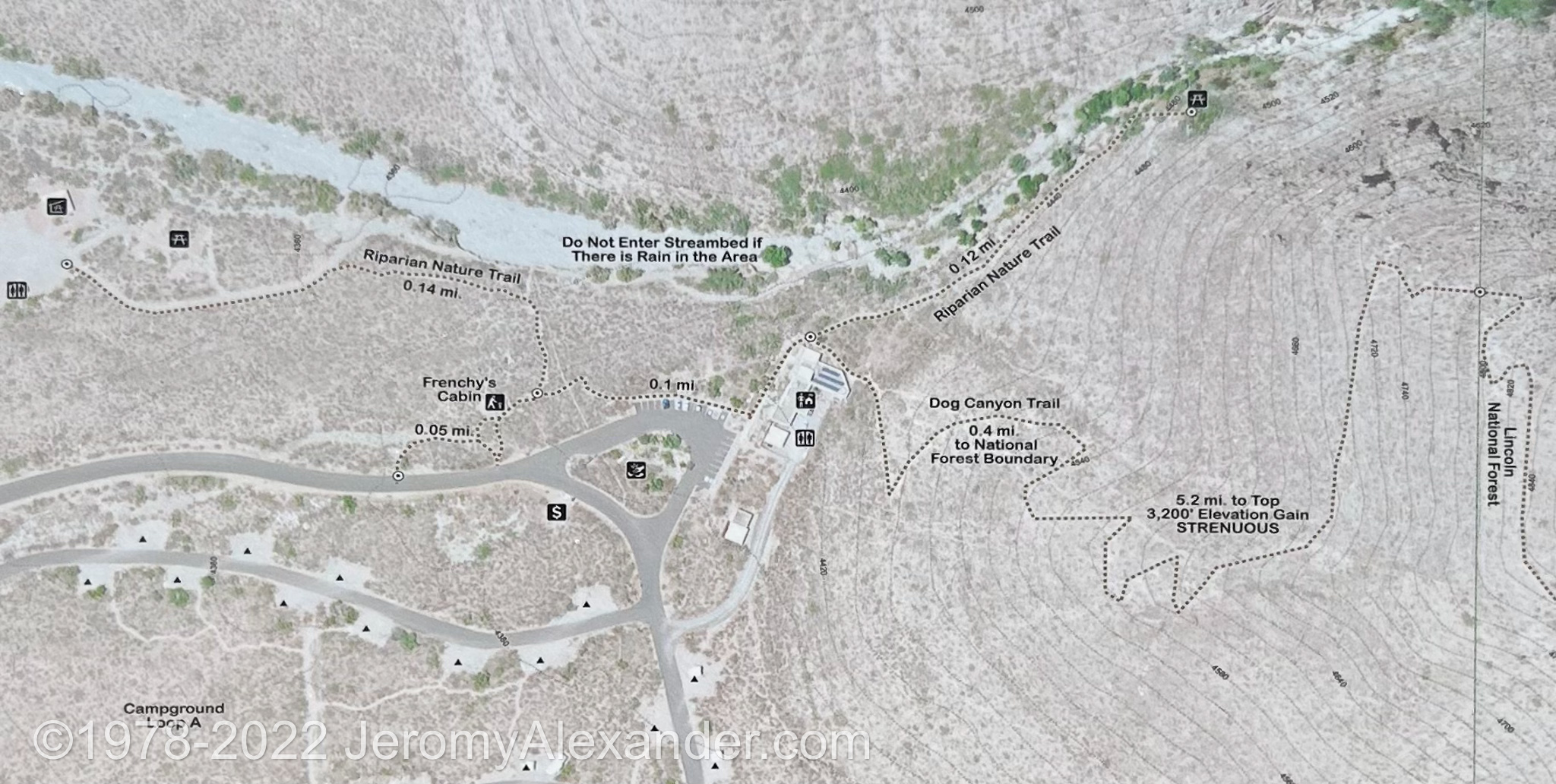
A gentleman I had met last night had mentioned the trail ahead did go straight into the canyon (this was before I’d looked at the map myself, pictured just up there.) Yet, he suggested at the fork, to go left into the canyon, rather than right, up the mountain. That sounded perfectly logical to me, so this morning in an exploratory mood I checked no more maps, just finished my tea and breakfast, turned off the TV (yeah, twenty seven channels here, and I still just listened to Cold Case Files while I ate.)
And probably spend another hour or two at least sitting in my car out of the sun (once it rose over the mountains, it was right in my face.) In my car I checked my email, Facebook, did some FAFSA work for my son (had to find my user/pass to get his aide submitted.. and in the process learning that mine was approved as well.. I have six six hundred dollars sitting in an educational bank for my use,) and you know, generally just let some time evaporate while I played on the Internet. Oh, finally have my data limit back on my phone.. one hundred gigs went way too fast last month in the time after I rediscovered Pluto.TV and before I got the OTA TV. Now I have to remember to Pluto only on my phone directly, not via the hotspot (and it’s one hundred gig limit.)
Anyway, I knew even a four mile hike (if I made it half way, a reasonable goal) would only take four hours or less, even at a ridiculously slow pace of a mile per hour, so I was in no rush to leave, rather I wanted to make sure everything was just right. I packed my small backpack, my camera, a scope and compass (left the pen and paper for some reason,) a half gallon of water, my tripod chair (it’s a crutch.. if I have it, I know I can stop and sit anywhere I need to,) and my radio. Actually, the radio is what got me sidetracked on my laptop, as I’d been waiting for today to reset my pi digipeater up to the wifi so I could once again be beaconing out my positions to the Internet as well as via local RF.
Anyway, just after lunch I finally got under way, my trek poles collapsed and holding them both in one hand. The first few hundred yards were pretty easy, the same as Brantley Lake, gravel trails with some protruding bedrocks- a LOT more foliage here though (though no trees as yesterday going through Cloudcroft.) So much, that you really have to stick to the trails or you’d be pushing yourself through the prickered bushes (again, almost everything has prickers here.) Once I got past the visitor center, the trail got more difficult – I knew it would, had read the reviews online: the first half mile was rough, then it got better, and the last half mile was rough.
So I kept pushing forward walking along the dry river bed at the base of the canyon. It was beautiful, every where I turn this scenery is amazing. At one spot the trail narrowed severely, the left side washed out into the river bed below. It didn’t look fresh and with- oh yeah, the trek poles got extended about a hundred yards ago, the first down hill rocky slope- the trek poles, I was able to do some very careful lateral side steps over the trench on what remained of the trail.
A bit further down the trail seemed to dead end at the river bed, just swampy marsh in front of me (oh yeah, this river bed, I found, was not exactly dry, just the smallest creek trickled through it.) Yet beside trail were some perfect sitting boulders to sit and watch and listen to the creek (or is it a brook?) which was maybe a twenty foot drop to my left. In the river were some giant RV sized boulders that I couldn’t imagine were part of the path. As I sat I noticed up the slope to my right was another higher path- as I noticed the hiker walking along it.
Hi and hello’s and what a beautiful day, etc, when I mentioned I wasn’t sure where my path went next- over the boulders (down into and across the almost dry river bed. She smiled (she looked like an experienced hiker,) and pointed out politely that from her point of view, it looked like the trail went down into the riverbed, then crooked up into a wooded area that I couldn’t see into from my point of view. I thanked her and mentioned that her path looked a little easier, she smiled and said it was, and added that she had never taken the lower path. She also added that I could cross over onto the higher path up ahead at the picnic table.
Not wanted to pester her with too many questions I bid her well and continued to sit and ponder my now known path ahead. The walk down the bedrock boulders was a bit scary, I absolutely could not have done it without the trek poles- or sliding down on my butt! Anything but tumble forward I told myself. At the bottom, several large steps over the marsh onto exposed tree roots, then back up a few medium boulders- these I had to climb on my hands and knees until I was finally back onto a reasonable flat gravel trail.
Oh, I was glad it was only the first half mile that would be this hard. Shortly ahead I saw the picnic table area at the end of the high trail. Walk around to the other side of it, I hoped there was an easy way up. There was a stone stairway of sorts, yet I still had to go up with my hands and feet. From the higher vantage point, I again couldn’t see where the trail went forward- yet the same woman was now at the picnic table eating her lunch.
 A simple question with an easy response: it doesn’t go forward, only loops back on the high trail she came in on. Asking about the four mile trail, she said oh- that’s the high trail at the top, as she pointed all the way up the southern mountain of dog canyon. Oh, I said (at this point really wishing I would have checked my maps,) and wished her well and headed back on the high path. The high path was a much easier walk too – and had an amazing view! By the visitor center, around an old cabin with some local history (Frenchie!) then back to the site. Over an hour walk and just under three quarters of a mile.
Now, I’ve checked my maps. I included it above. The four mile trail with the difficult first half mile is not the the trail into the canyon. That is just a half mile loop from the visitor center to the picnic table (the extra for me was the bit to my site and back.) The dog canyon trail starts by going UP THE MOUNTAIN behind my site. UP THE MOUNTAIN.. WTF am I thinking. I think I’m going to fall off of it, as least tumble down for a ways- if not on the way up, most certainly on the way down. From my campsite it’s about a half mile (twenty six hundred feet) from my site to the border of the state park and the national forest.
Yesterday I drove through the National Forest, my next big walk, I want to walk into it. Up that mountain.
Okay, maybe it’s just a hill- it looks huge doesn’t it- the half mile trail up the peak pictured has an elevation gain of four hundred feet from where I stand. The next four and half miles (through the forest) goes up another thirty five hundred feet. WTF am I thinking? I now what I was thinking- of taking a four mile walk through some nice scenery. You know, from the nice gravel trail. There is no nice gravel trail going up that mountain.
Other news? oh a nice chat with the ranger this morning as he drove by doing his rounds. Asking how long I planned to stay, I said I’d probably max out the limit. Well, not in this site he said, though he was quick to start flipping pages on his clipboard. Yep, another group has it booked for Saturday, he flipped a few more pages back and forth until he found another spot. Apparently they do have a primitive area here, inside of the park separate from the dispersed area. Saturday I’ll move up there and be all set for a fourteen day stay.
How long will it take for me to climb a mountain? How long for me to decide if this is just a hill?
Okay, that’s about it and usually I’d say “Time to rest.” to close, yet.. it’s actually kind of early, six forty nine, tonight I thought I’d change up the routine and do my OT (this blog,) before dinner, rather than after. I’ve cut more than a few posts short in the last week or so, and I’m sorry about that. I enjoy writing and I don’t like when I have more details to write about than I do mental energy to write. So an earlier post.. also, though I know I’ll walk a bit more tonight, I know I’m not going up that mountain today. That is a pack a lunch and leave in the morning kinda thing.
Okay, till tomorrow.. time to eat.
1 thought on “Up the mountain?”